
CASE/08 / Aviation
United StatesA live view of the airside, instead of the radio
A real-time dashboard gave ground teams at several US airports one shared view of vehicles, luggage, alerts and incidents, in place of walkie-talkie coordination.
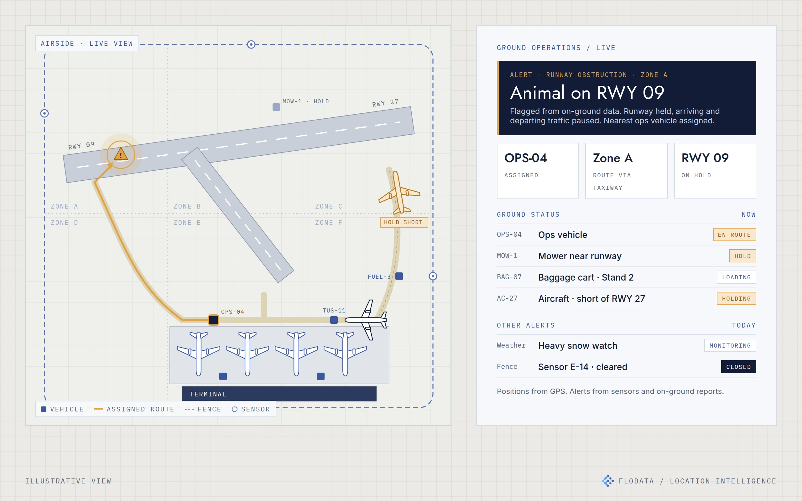
01 / THE ASK
The decision behind the brief.
The client runs ground operations at several airports in the United States. Vehicle movement, luggage handling and ground control were coordinated by walkie-talkie. Nobody had a live picture of where vehicles, luggage or problems were. The client wanted ground teams to see the airside, not just hear about it.
02 / WHAT WE FOUND
What the work revealed.
Radio works for one call at a time. On a busy airside it meant confusion over who was where, slow responses to incidents and safety risk when a runway or perimeter problem could not be located quickly. The problems that mattered were specific and recurring: something on a runway, a breach in the fence, weather forcing a shutdown, two vehicles routed into the same space and ground staff working from different information.
03 / WHAT WE BUILT
One live view of the airside, built around real scenarios.
Bring the data together
We combined GPS positions from ground vehicles, sensor data and on-ground reports and feeds into one stream.
Track vehicles and assets live
Every tracked vehicle and asset appears on a single map of the airside, divided into zones, in real time.
Raise alerts where they happen
The dashboard raises alerts for weather, fence breaches and animal sightings, and shows each one at its location.
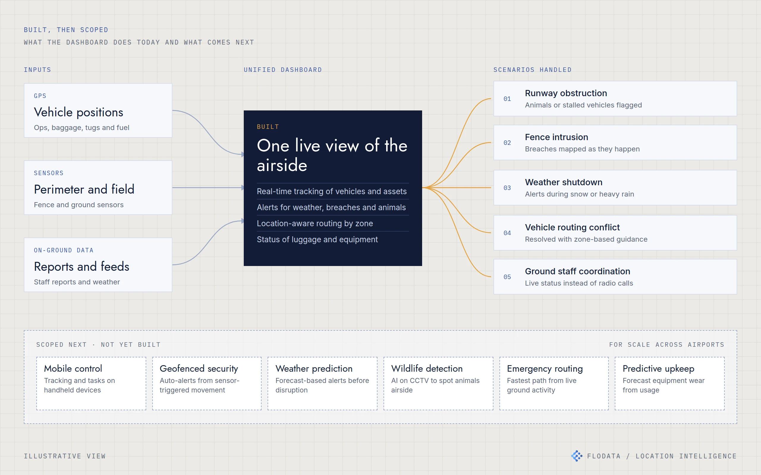
GPS, sensors and on-ground data feed one dashboard that handles five recurring scenarios. The capabilities below the line were scoped for the next phase and are not yet built.
Route by location
Location-aware routing gives teams zone-based guidance, so vehicle conflicts are resolved before they become incidents.
Show status at a glance
Teams see the status of luggage and equipment on the same screen as the alerts.
The five scenarios it handles
Runway obstruction alerts for animals or stalled vehicles. Fence intrusions mapped as they happen. Weather-based shutdown alerts during snow or heavy rain. Vehicle routing conflicts resolved with zone-based guidance. Ground staff coordinated through live status instead of radio calls.
04 / THE RESULT
From radio calls to a shared picture.
Ground teams now work from the same live view. Incidents can be seen and located as they happen, and the nearest team can be sent with guidance instead of directions over the radio.
[CONFIRM: any measured result, such as response time to incidents, fewer routing conflicts or the number of airports live. If there is none, keep this as written.]
SCOPED, NOT DELIVERED
Next phase
With the client we scoped a second phase to scale across more airports: mobile control on handheld devices, geofenced security alerts, forecast-based weather alerts, wildlife detection from CCTV, emergency vehicle routing and predictive maintenance for ground equipment. [CONFIRM: has any of this been built since?]
05 / ENGINEERING DETAILUnder the hood
- GPS, sensors and reports
- One live airside map
- Alerts by location
- Zone-based routing
- Shared status for ground teams
Inputs. GPS from ground vehicles, perimeter and field sensors, and on-ground data streams including staff reports and weather.
Live map. Airside layout split into zones, with tracked vehicles and assets shown in real time.
Alerting. Rules raise alerts for runway obstructions, fence breaches and weather conditions and place them on the map.
Routing. Zone-based guidance for ground vehicles to avoid conflicts and reach incidents.
Status. Luggage and equipment status alongside live positions.
Stack. [CONFIRM: mapping library, database, how GPS and sensor data arrive, hosting.]
- GPS vehicle tracking
- Sensor integration
- Live airside map
- Location-based alerting
- Zone-based routing