
CASE/01 / Real estate
IndiaA usable system from generations of plot records
Scanned property files became a linked register, with every ownership change traced to its source and every plot on the map.

01 / THE ASK
The decision behind the brief.
A large cooperative housing society needs to answer a simple question for every property it manages: who holds this plot today, and how did they come to hold it? The answer exists only in paper files kept for more than six decades. Without a reliable answer, every transfer, membership update and legal query starts with a manual search through folders, and nobody can say with confidence where the paper does not add up.
02 / WHAT WE FOUND
What the work revealed.
Close to 2,000 properties had been sold, inherited, split between heirs and sold again, often in fractional portions. Their files mixed allotment papers, sale deeds, share certificates and letters in formats that changed across the decades. Some records were incomplete. Some disagreed with each other. Digitising the pages would only have given the society a searchable archive of the same confusion. The real problem was to rebuild each property's chain of ownership and show where the paper could not support it.
03 / WHAT WE BUILT
Reconcile the record. Preserve the history.
Digitise and classify the archive
Every property file was scanned, OCR-processed and classified. The data was then extracted in two passes. The second pass refined and validated the first, and a file only counted as ready once it had been cleaned and quality-checked.
Rebuild the chain of title
Each property carries an ownership history: every allotment, sale and inheritance in order, with the date, deed number, the parties on each side, the transfer type and the portion that changed hands. Fractional holdings are tracked through each split, so current ownership is calculated from the history rather than typed in by hand.
Link every entry to its source
Each ownership event links to the scanned pages it came from. The legacy scans are kept alongside documents uploaded through the new workflow, so the original paper is always one click away.
Show what is missing
Each property has a document checklist across title, society and membership, construction and other papers. Missing documents are counted and shown, not hidden. The society can see exactly which files need chasing.
Put every plot on the map
Every plot is drawn on an interactive map. Click a plot for a summary, or go straight to its full record.
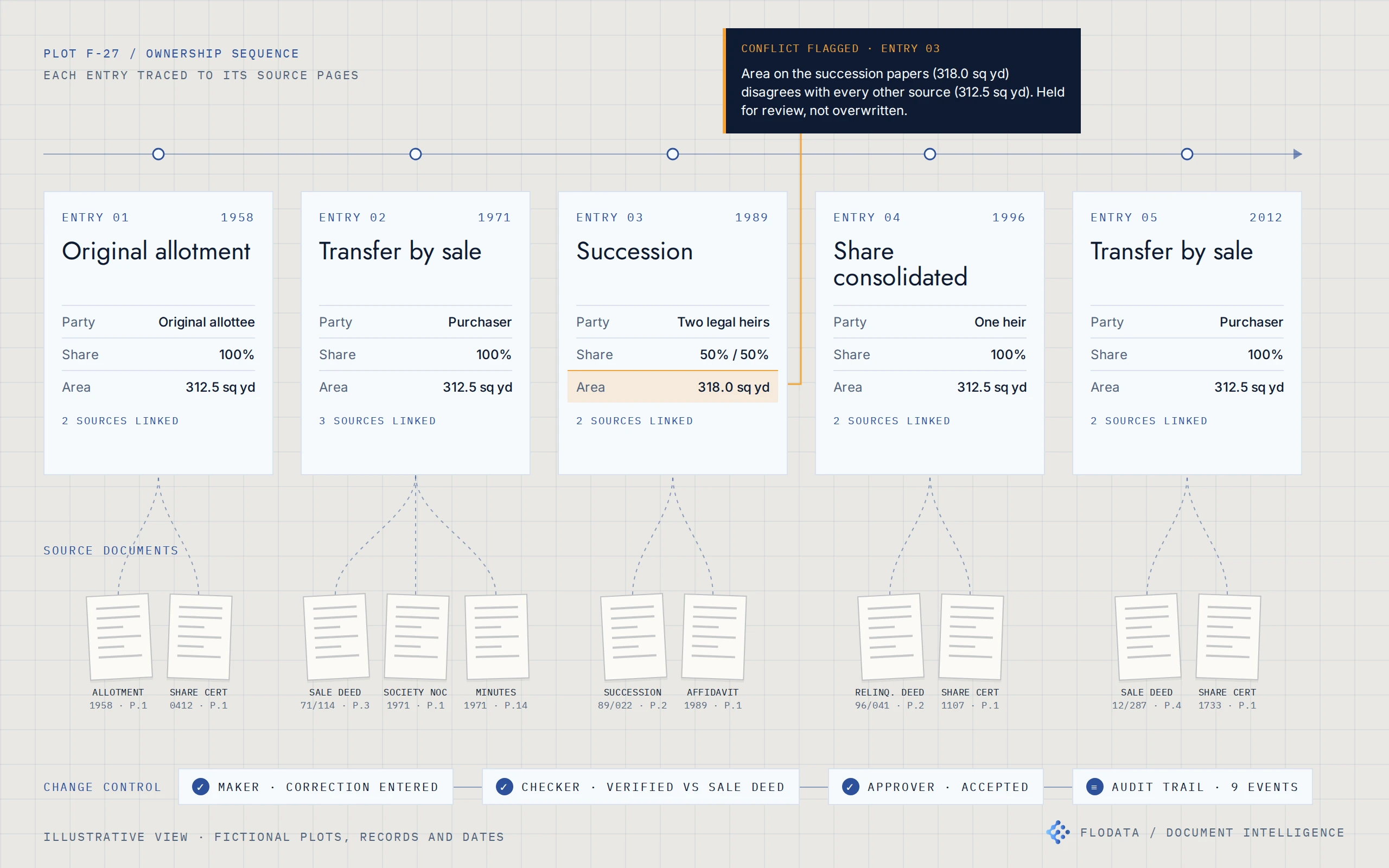
Each ownership entry traced to its source pages, with conflicts held for review rather than overwritten. Illustrative view with fictional data.
Controlled change
After go-live, changes run through defined workflows for ownership transfers, membership updates and document uploads. Every change passes maker, checker and approver, and every action is logged.
04 / THE RESULT
One register, traced to its paper.
The society now opens any property and sees its current holders, its full ownership history, the source pages behind each entry and the documents still missing.
05 / ENGINEERING DETAILUnder the hood
- Scanned property files
- Classify and extract
- Ownership chain with source links
- Map and register
- Controlled change
Document linkage. Each property record holds its overview, ownership history, share certificates, club memberships, documents, construction details and legal details. Every ownership event carries its date, deed reference, parties, transfer type and portion, plus links to the scanned source records. Legacy scans and new uploads are stored separately and both are linked to the property.
Conflict resolution. Conflicts are not resolved by the software choosing a version. Gaps and discrepancies found during extraction were logged and resolved with the society's administrators. The ownership history can be reordered and current ownership reprocessed once the correct sequence is agreed.
Review controls. Two-pass extraction with validation and quality checks before a record is marked ready. After go-live: role-based access, maker, checker and approver workflows, an incoming update queue with status tracking and an application log of every view, login and change.
Spatial layer. Plot polygons on a web map, each linked to its property record, with type filtering and a pop-up summary.
- OCR and document classification
- Two-pass AI extraction with validation
- Chain-of-title register
- Web map with plot polygons
- Maker, checker and approver workflows